
The 11 most famous mountain passes of Giro d'Italia
The Giro d'Italia is one of the most important cycling races in the world.
The best riders from all over come to Italy to compete in this three-week long event. And every year, the race takes them through some of the most beautiful and challenging mountain passes in the country.
For us, is a great inspiration source for our travel plans. This mountain passes are not only challenging but also some of the most stunning places.
In this blog post, we will explore the 10 most famous mountain passes of Giro d'Italia. From the Passo dello Stelvio to the Passo Gavia, these are the places that have made the race what it is today.
The Passo dello Stelvio
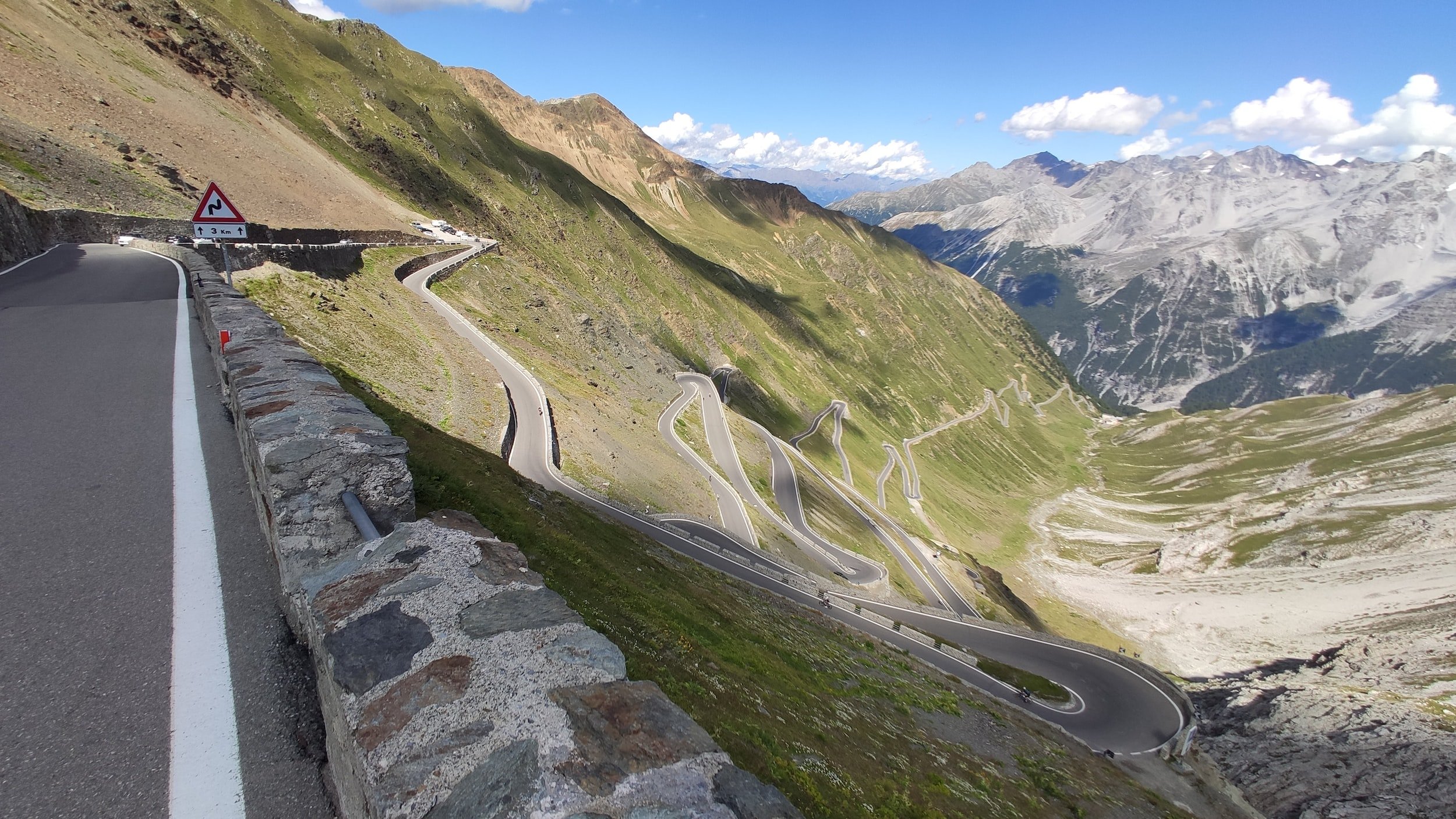
The Passo dello Stelvio, located in the Italian Alps, is one of the most famous mountain passes of the Giro d'Italia. The pass is known for its steep gradients and its challenging switchbacks.
The Passo dello Stelvio has been used in the Giro d'Italia many times and has been the scene of some of the race's most dramatic moments.
Distance: 21.7 kilometers long.
Elevation Gain: 1832 meters above sea level.
Average Gradient is 7.5%.
The Passo di Gavia
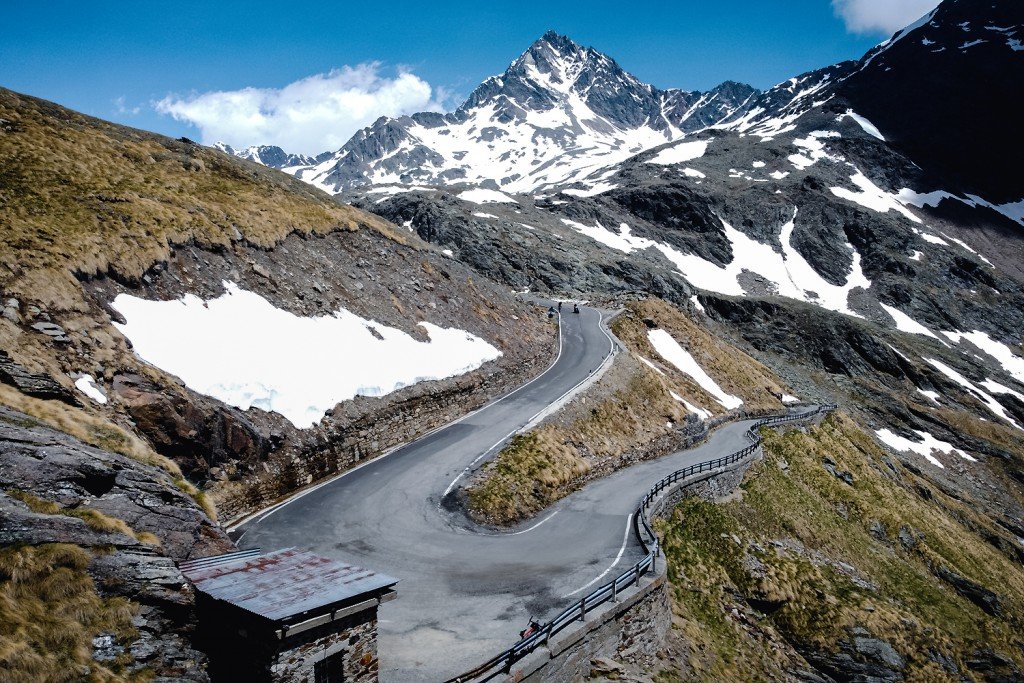
Photo credit to VDB - Climbfinder
The Passo di Gavia is one of the most famous mountain passes in Italy. It is located in the Lombardy region of Italy and is part of the Giro d'Italia.
The pass has an elevation of 2,618 meters (8,599 feet) and is known for its scenic views. The pass was first used in the Giro d'Italia in 1986 and has been used several times since then.
Distance: 19.6km long
Elevation Gain: 1458 meters above sea level.
Average Gradient is 7.4%.
The Pordoi Pass

Photo credit to giroditalia.it
The Pordoi Pass is one of the most famous mountain passes of Giro d'Italia. It is located in the Dolomites, in the province of Belluno, Italy. The pass is 2,239 m above sea level.
The Pordoi Pass was first used in the Giro d'Italia in 1960. Since then, it has been used 27 times in the race. The most recent stage that finished on the Pordoi Pass was Stage 16 of the 2014 Giro d'Italia.
There are several reasons why the Pordoi Pass is such a popular climb among cyclists. First, the scenery is simply breathtaking. The pass is surrounded by some of the tallest peaks in the Dolomites, including Marmolada (the highest mountain in the range).
Second, the road surface is very good, making it a fast and enjoyable climb.
Finally, there are several great places to stop along the way up for food and drink, which makes it a perfect place to take a break during a long ride.
Distance: 11.9km long
Elevation Gain: 791 meters above sea level.
Average Gradient is 6.6%.
The Passo di Falzarego
The Passo di Falzarego is an iconic mountain pass in Giro d'Italia. The pass is located in the Dolomites, a mountain range in northeastern Italy.
The Passo di Falzarego is known for its steep gradients and scenic views. The pass has been used in the Giro d'Italia race several times, most recently in 2013.
Distance: 19.3km long
Elevation Gain: 1111 meters above sea level.
Average Gradient is 5.7%.
The Monte Zoncolan

Photo credit to giroditalia.it
The Monte Zoncolan is one of the most difficult climbs in professional road bicycle racing with gradient of up to 22%.
The Monte Zoncolan was first used in the Giro d'Italia in 1987, and has been used eight times since then.
It is located in the province of Udine, in the northeastern Italian region of Friuli-Venezia Giulia.
The Monte Zoncolan has been won by some of the greatest cyclists in history, including Marco Pantani, Vincenzo Nibali, and Nairo Quintana.
Distance: 9.8km long
Elevation Gain: 1206 meters above sea level.
Average Gradient is 12.3%.
The Passo di Valparola
Photo credit to Wiffe - Climbfinder
The Passo di Valparola is a mountain pass in the Dolomites in northern Italy. It is one of the most famous mountain passes of Giro d'Italia, being used several times in the race.
The pass itself is relatively easy to climb, and the views from the top are stunning, with the Dolomites stretching out in all directions. Is a great location to be during the race, it's well worth heading up to watch the riders come through.
Distance: 17.1km long
Elevation Gain: 1004 meters above sea level.
Average Gradient is 5.9%.
The Passo del Tonale
The Passo del Tonale is located in the province of Trentino, in northern Italy. The pass is named after the nearby town of Tonale. The pass was first used in the Giro d'Italia in 1910 and has been used regularly since then.
The Passo del Tonale is a very popular tourist destination, especially in winter when it is a popular ski resort. The road over the pass is very scenic and has some great views.
Distance: 29.7km long
Elevation Gain: 1199 meters above sea level.
Average Gradient is 4%.
The Passo di Rolle
The Passo di Rolle is located in the province of Trentino, in Northern Italy and It's a popular destination for both road cyclists and mountain bikers.
The Passo di Rolle is one of the highest paved roads in Europe, reaching an altitude of 2,239 meters (7,349 feet). The road was first built in 1894 and was paved in 1914.
The road to the Passo di Rolle starts from the town of Mezzocorona, at an altitude of 650 meters (2,132 feet). From Mezzocorona, the road winds its way up through forests and meadows. After about 10 kilometers (6 miles), the gradient starts to increase and the road becomes much steeper. There are several hairpin bends as the road climbs up to the pass.
At the top of the pass, there are stunning views of the surrounding mountains. On a clear day, you can even see as far as Venice! The Passo di Rolle is a popular spot for tourists, so there are several restaurants and cafes at the top of the pass.
Distance: 20.3km long
Elevation Gain: 965 meters above sea level.
Average Gradient is 4.8%
The Tre Cime di Lavaredo

The Tre Cime di Lavaredo is located in the Dolomites, in Northeastern Italy. The Tre Cime di Lavaredo is considered to be one of the most difficult stages of the Giro d'Italia, due to its high altitude and steep grades.
The first rider to conquer the pass was Italian Fausto Coppi, who did so in 1949. Since then, the Tre Cime di Lavaredo has become one of the most iconic stages of the race, with many riders dreaming of victory on its slopes.
Today, the pass is still as challenging as ever, and riders who are able to conquer it are sure to have an incredible story to tell.
Distance: 7.5km long
Elevation Gain: 656 meters above sea level.
Average Gradient is 8.7%
The Blockhaus

Photo credit to giroditalia.it
The first mountain pass of the Giro d'Italia is the Blockhaus. The race starts in Bologna and heads northeast toward the Apennine Mountains. It is the highest point of the race at 2,015 meters (6,611 feet) and usually considered one of the most difficult stage.
In recent years, the Blockhaus has been used as the final mountain stage of the Giro d'Italia. In 2017, it was stage 14 and Nairo Quintana (Movistar) attacked on the final kilometer to take the win. In 2018, it was again used as the penultimate stage and Simon Yates (Mitchelton–Scott) soloed to victory after attacking on the descent from Monte Zoncolan.
Distance: 26.5km long
Elevation Gain: 1848 meters above sea level.
Average Gradient is 7%
The Colle delle Finistre
The Colle delle Finistre is located in the province of Cuneo, in the Italian Alps. The pass is situated at an elevation of 2,715 metres (8,907 ft) above sea level and is one of the highest paved roads in Europe.
The Colle delle Finistre was first used in the Giro d'Italia in 1949 and has been included in the race a total of 19 times. It was most recently climbed by the peloton in 2014. The climb is typically ridden from the town of Pinerolo, although it can also be approached from Sestriere.
The Colle delle Finistre is a winding mountain road with several hairpin bends. The road surface is generally good, although there are some patches of gravel which can be tricky to negotiate.
The views from the Colle delle Finistre are truly breathtaking, with sweeping panoramas of the Alps stretching out before you. As you wind your way up the pass, you'll catch glimpses of Mont Blanc, Monte Rosa and other iconic peaks.
If you're lucky enough to have clear weather, you might even see as far as Turin or Milan on a really good day!
Distance: 18.8km long
Elevation Gain: 1702 meters above sea level.
Average Gradient is 9.1%
Conclusion
This is just a few of the mountain passes that pro cyclists in the Giro D'Italia have to climb and a great checklist for any cycling enthusiast. Is you are able to travel to Italy during the race make sure you experience it first hand, it is a truly unique and amazing event.